The support forum is temporarily read-only. For urgent requests, please email contact[at]psyberia.net

Zoom in last resolution

Any question about the app? Ask it here
Post Reply
Aliamba
Posts: 4
Joined: Sun May 16, 2021 8:46 pm

Zoom in last resolution

Post by Aliamba »

Hi, i use AlpineQuest a lot when driving in the woods. While on the ESRI Imagery, i can zoom to 17/18, but when i try to zoom more, it goes to 18/18 but becomes all white tile "Map data not yet available" written. I just want to zoom with or without zoom level 18. I would like to zoom into the last resolution like i do with OpenTopoMap for example. I get to 17/17 and can still zoom with current resolution. I think you get the point, i would like to know if anyone have a solution for this?
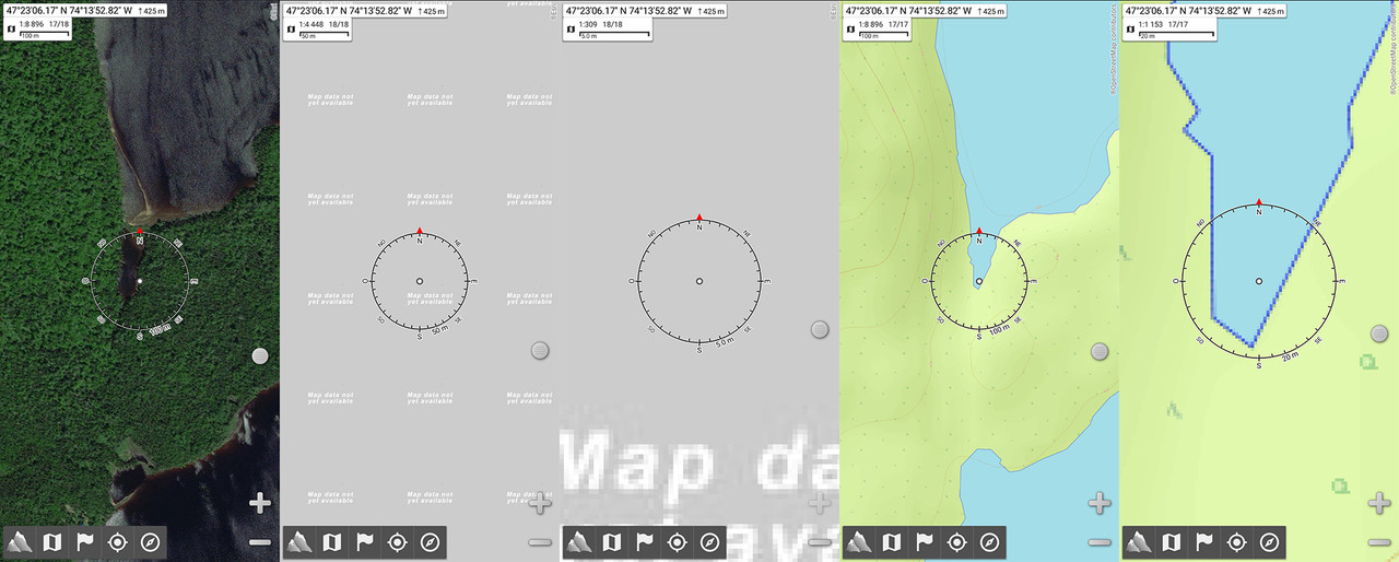
Image

Also, is there a way for track recorder to add point every x meters instead of every x seconds? I think i've seen this in Canada Topo Map. Seconds delay is good for hiking but i think distance would be better for driving my truck in forestry roads.

Thanks
Psyberia-Support
Site Admin
Posts: 6408
Joined: Wed Apr 14, 2010 9:41 pm

Re: Zoom in last resolution

Post by Psyberia-Support »

Concerning the first problem, I'll try to do something in the next update.
The problem is that this map return an image even if no data is available, so the application is not able to tell if it's a real aerial image or just a message...
On the contrary OpenTopoMap does not send any data if the map is not available.

Concerning the track recorder, no it's not possible.
Do you like AlpineQuest ? Leave a small comment on Google Play !
Aliamba
Posts: 4
Joined: Sun May 16, 2021 8:46 pm

Re: Zoom in last resolution

Post by Aliamba »

Thank you! I don't know how the app is built but when i add ESRI Sattelite in QGIS for exemple, i can set the maximum zoom level to 17 instead of 18. Maybe adjusting this zoom level in AlpineQuest would solve the problem. Again, i don't really know how it works, thanks for looking into this problem.
Psyberia-Support
Site Admin
Posts: 6408
Joined: Wed Apr 14, 2010 9:41 pm

Re: Zoom in last resolution

Post by Psyberia-Support »

You can manually edit the map configuration file using any text editor and remove the zoom level 18. Display the details of the map and check the data file section to get the ".aqx" file path.
It's here because this zoom level is available at some places.
But next update will be fine.
Do you like AlpineQuest ? Leave a small comment on Google Play !
Post Reply